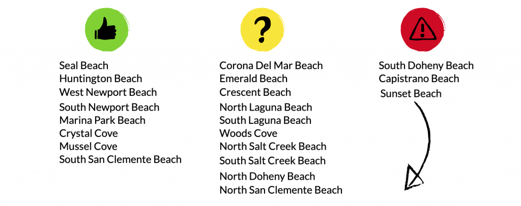
In the Summer of 2019, high school students Jenna Kim and Gwen Sanders started a project associated with measuring the change in beach width across Orange County. They collected their data using satellite images from Google Earth and then created graphs for the change in beach width using MATLAB. Then they created a system of rating the beaches into categories of red (at risk), yellow (concerning), and green (not at risk). The classifications are shown below.
How can we prevent Orange County beaches from disappearing within our own lifetime?
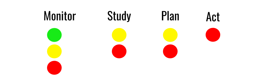
The Four Steps to Success
Monitor –
Something to do at all of the OC beaches, no matter the ranking, is to monitor them. We need to know how each beach is changing every year, so if a green beach starts to decrease in width, it can be moved to yellow or even red and appropriate action can be taken. This includes measuring the amount of sand above and below water. Various technologies can be used including Unmanned Aerial Vehicles (UAVs), ground-based light ranging and detection systems (lidar), sonar systems for underwater measurements, and traditional survey methods. In addition, measurements of sediment supplies from nearby streams feeding the beaches can be monitored. Other activities that would be important would be to measure the size distribution and density of beach material, measure beach visitation and activities both onshore and offshore, and monitor ecosystem health using suitable indicators.
Study –
The next step beyond monitoring beaches is to study and analyze them. This includes studying sediment supplies such as rivers and sand from other beaches that is moved by waves and ocean currents. It is also valuable to study how each beach is exposed to waves from different directions, onshore processes like watershed runoff, and long term issues like sea level rise and changes in wave climate. These studies are important for identify the best interventions (beach nourishment, dune restoration, living shorelines). A long term perspective if also valuable and can be gained by analyzing historical trends in sand volumes and beach width, especially in relation to storm events, shoreline protection measures, and watershed development including construction of dams.
Plan –
The information collected from monitoring and studying can aid in making plans for action. However, it is important to build a network of stakeholders for input on management, and develop a process of engaging stakeholders in decision-making. Secondly, early planning should also involve identify sources of sediment that could be used to artificially nourish the beach, and understanding the necessary permits that are needed to implement a project and the timelines to get them approved. Third, a funding strategy is needed and effort should be taken to review, discuss, deliberate and rank possible interventions in consultation with stakeholders and develop implementation plans. Lastly, it is important to educate the public about the beach erosion threats and possible interventions.
Act –
This is the time to put plans into action. Projects may not always be successful, but steps must be taken to protect these important resources. Additionally, it is important to monitor and study the impact of interventions and adapt over time for greater success.

More information can be found on our original site: https://sites.google.com/iusd.org/ocbeaches/home?authuser=0