Key Take Aways:
- New research article by UCI characterizes sand movement along the coast to identify areas where beaches may grow or shrink
- By leveraging satellite imagery and nearshore wave data, research reveals opportunities to inform coastal management strategies with a better sense for the optimal scale at which to tackle beach erosion
Southern California is home to some of the most famous beaches in the world, which are the backdrop for American beach culture popularized through music, films, television, and surfing. These sandy beaches provide recreational opportunities, protect infrastructure, support coastal ecosystems, and are central to the heritage of coastal communities. Unfortunately, this valuable resource’s very existence is threatened, and the future of sandy beaches is uncertain.

There are many factors contributing to beach loss. As public infrastructure and private properties were developed along the coastline in the 20th century, the natural migration of beaches was prevented, effectively ‘squeezing’ beaches between rising seas and fixed structures. Additionally, the supply of sand to beaches has been disrupted as watersheds were urbanized and rivers channelized- up to 66% of historic sand inputs have been cut off. These issues will only be exacerbated by accelerated sea level rise and uncertainty in future weather and wave climates. The combination of natural and anthropogenic processes, along with the complexity of the coastal zone, makes understanding beach dynamics difficult.
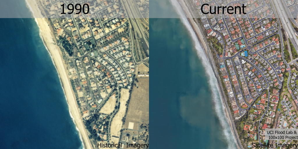
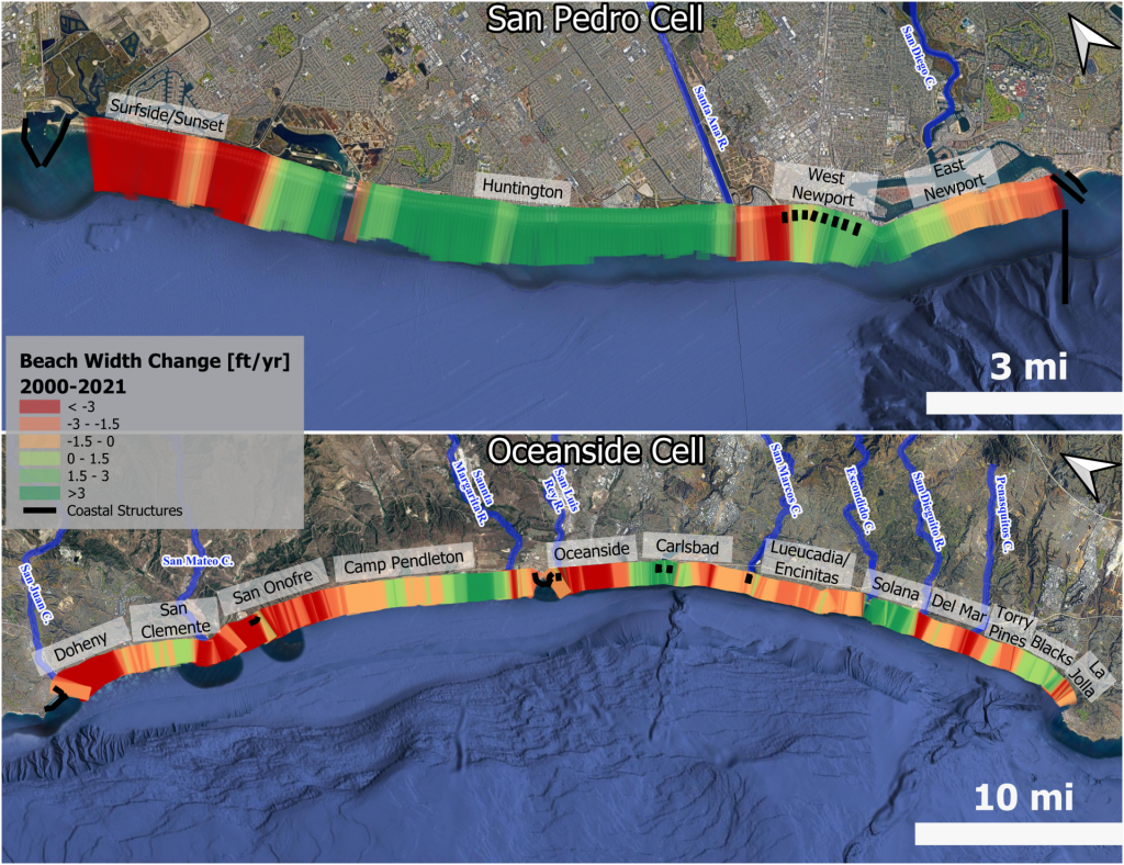
Recent data sources have emerged which offer us a much more detailed picture of beach loss. First, nearly four decades of satellite imagery allow us to see precisely where beaches are narrowing, and where they are widening. In fact, satellite data show that Huntington Beach has been widening at a rate of roughly three feet per year for the past several decades. On the other hand, beaches near Dana Point and San Clemente in south Orange County have been narrowing at nearly the same rate over the same period of time. This reinforces earlier work by others showing that beach loss is much more complicated than a proportional response to sea level rise: local sand supply and coastal structures that alter the movement of sand are important considerations.
Secondly, detailed wave data available along the coast of California is provided by the California Data Information Program (CDIP), operated by Scripps Institution of Oceanography. Information of nearshore waves can help us understand why specific beaches are narrowing while others are widening. Wave data allow us to estimate the flow of sand along the coast, a process known as longshore drift. In other words, longshore drift is a coastal current that moves and redistributes sand from one beach to neighboring beaches.
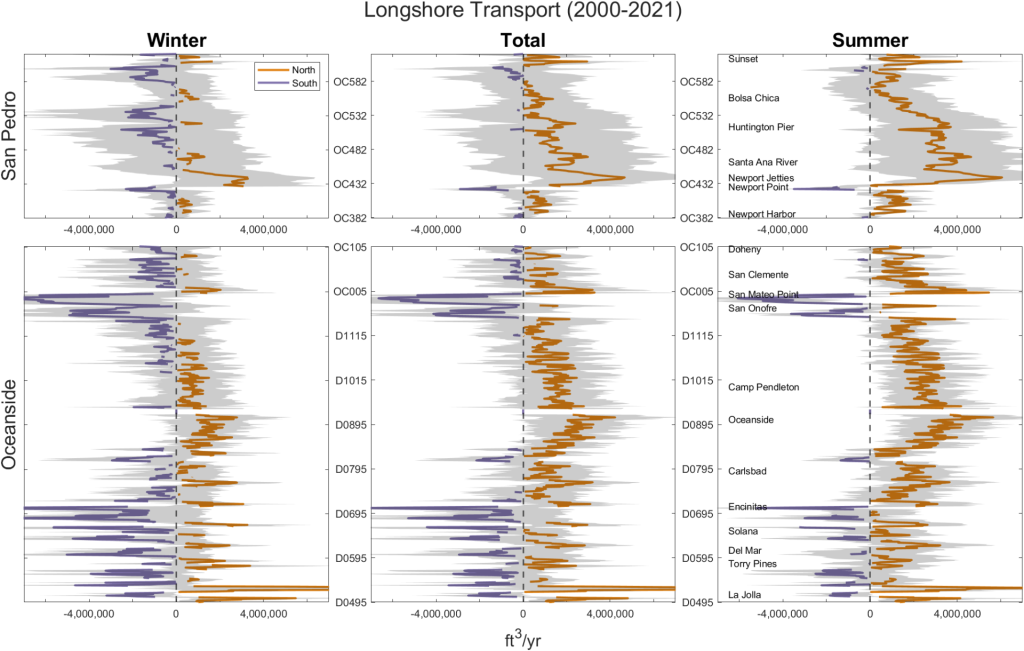
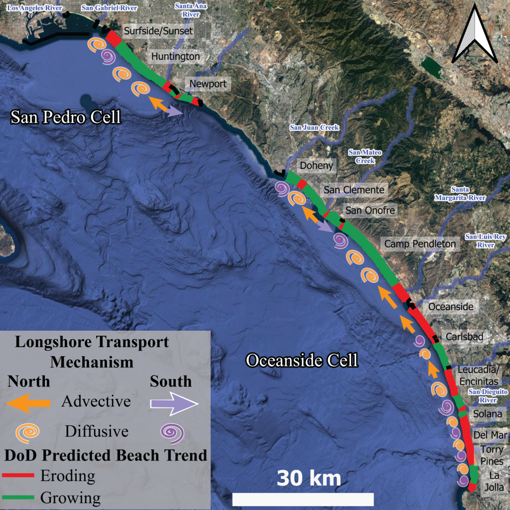
We can use longshore drift to see the direction sand travels and find areas where sand accumulates over many years. With the development of a new method to calculate gradients in longshore drift (also known as divergence of drift) using physical features and characteristics of longshore transport, we show improved estimates of the drivers of beach change compared to previous approaches which utilize uniform distances (view article for more details). Our analysis shows that some areas, like Huntington Beach, are in an area of sand accumulation, while other areas, such as Sunset Beach, are where longshore drift depletes sand. This analysis of sand accumulation or depletion agrees well with the observed beach change from satellite imagery. More broadly, our work points to the best spatial scale to manage coastal erosion. We found that given enough sediment, beach dynamics will largely follow patterns of sediment accumulation and depletion directed by longshore drift. That is, long term beach loss in southern California is largely driven by loss of sand supplies, such as through reduced natural inputs of sand to the coast, or increased rate of erosion due to coastline developments and armoring.
Rivers and cliff erosion are natural sources of sand for beaches, but artificial nourishments are increasing seen as a strategy to help maintain our beaches- albeit an increasingly costly strategy. However, we don’t always know which rivers are important for supplying sand to certain beaches, or even which beaches would benefit from specific nourishment projects. Where can we place sand along the coast such that sand offers long lasting benefits to coastal communities?
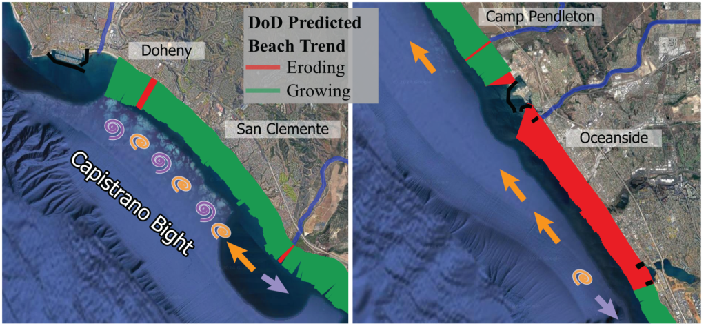
With access to both satellite data on beach change and wave data predicting the direction of longshore drift, we can step back and see where sand is likely to go. This is critical from a management perspective because this data indicates which communities need to work together on plans to manage their natural resources. For example, our data and modeling suggest that the Capistrano Bight, which stretches from Dana Point to Cottons Point, is a sub-compartment of the coast partially separated from the rest of the coastline by divergent currents. This makes the area well-suited for beach nourishment projects, as longshore drift will tend to keep the sand within the bight and supporting multiple coastal communities. Alternatively, locations such as Oceanside may not be an ideal location for nourishment, because longshore drift moves sand north, and back into the harbor, away from beaches that desperately need sand.
Interestingly, the scale of littoral cells (coastal compartments useful for sediment management) that we see from our data is actually far smaller than suggested by recent statewide documentation of coastal processes (see Fig. 2.3). Also, our data suggests that the predominant direction of longshore drift along the coast is sometimes the opposite of what is suggested by the statewide documentation.
Sea level rise and changes to the frequency and intensity of storms are expected to put enormous stress on coastlines around the world, and urban areas are especially vulnerable due to impaired natural processes and functions. Communities and governments at every level will be pulled into conversations about ways to manage impacts, including plans for strategic retreat, plans to restore nature-based process, and plans to nourish beaches. Our research reveals an opportunity to direct these plans with better data and information, and a better sense for the optimal scale at which to tackle the problem.